https://www.facebook.com/media/set/?set=oa.1956515781318232&type=3
Dudhia
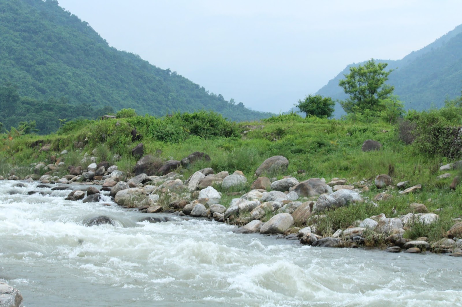
Dudhia is a small hamlet on
Mirik-
Siliguri highway on the bank of river Balason. Darjeeling Gorkha Hill Council's Gokul Wayside Inn used to be the favourite tourist joint at Dudhia, however it is closed at the time of writing this article. There are a several small tea shops where you can get other essentials.
Dudhia is a tranquil tourist spot. Above Gokul, as the hill starts rising from the plain, you can find Dudhia view point. You can see far and wide from here including great view of River Balasan.
it is a picnic place . very good view
Distance between Siliguri and Dudhia is 23.6 kms or 14.7 miles or 12.7 n miles
| Origin | Siliguri, West Bengal, India |
|---|
| Destination | Dudhia, West Bengal, India |
|---|
| Driving Distance | 23.6 kms or 14.7 miles or 12.7 n miles |
|---|
| Driving Time | 42 minutes |
|---|
| Flight Distance | NaN kms or NaN miles or NaN n miles |
|---|
On the table above you can see driving distance in various units namely kilo metres, miles and nautical miles.
alldistancebetween.com helps you find distance between any two addresses easily. You are provided with a very simple to use distance calculator. Knowing distance between your source and destination helps in planning out your journey properly.
You can view the route map below. Click and zoom on the map to understand the route better and plan better for your trip.
RUT MAP STEP WISE
SEE THE LINL FOR PIC AND VIDEO ..... IT IS PICNIC SPOT
PIC LINK
SUNTALEY KHOLA
PLASE NAME SUNTALEY KHOLA DISTT KALIMPONG
Suntalekhola or Suntaley Khola (also Suntaleykhola) is a small village and a tourist spot in the Kalimpong District of West Bengal. The altitude of the place ranges from 650 to 950 m. It gets its name from a small stream: Suntaley Khola. In Nepali language, Suntaleymeans orange and khola means stream. This place is nearly 5 km from Samsing, which is also a small picturesque serene village. The green patch on the left side of the way to Suntalekhola is amazing and holds many varieties of birds and butterflies.(from wiki pedia)
Distance between Siliguri Junction and Suntalekhola Samsing Nature Education And Wilderness Resort is 81.9 kms or 50.9 miles or 44.2 n miles
FOR HOTEL
HOME STAY
CALL 8436113769
2. HOME TOURISM CENTER
9475807290
8436067137
3 HOME STAY B.R GURUNG
8900512711
7551821007
8371039922
PLEASE SEE THE LINK
.....................................................
Rongo
Rongo is a village panchayat located in the Darjeeling district of West-Bengal state,India. The latitude 22.57 and longitude 88.36 are the geocoordinate of the Rongo.Rongo Perched on the top of a hill at an altitude of 4500 ft near the Bhutan boarder, Rongo or Rongu serve as the Headquarter of Cinchona Plantation under Kalimpong subdivision. Now Cinchona plantation is gradually giving way to rubber plantation. A tiny remote village having a market, post office and few houses in its locality, Rongo used to be a significant place for plantation and growing medicinal plants. Rongo offers fine-looking views of adjoining hills, dense forests and river valley of Jaldhaka.
The official language of Rongo
The native language of Rongo is Bengali, English, Nepali, Urdu and most of the village people speak Bengali, English, Nepali, Urdu. Rongo people use Bengali, English, Nepali, Urdu language for communication.
Rongo Sun rise time
Rongo village is located in the UTC 5.30 time zone and it follows indian standard time(IST). Rongo sun rise time varies -24 minutes from IST. The vehicle driving side in Rongo is left, all vehicles should take left side during driving. Rongo people are using its national currency which is Indian Rupee and its internationl currency code is INR. Rongo phones and mobiles can be accesed by adding the indian country dialing code +91 from abroad. Rongo people are following the dd/mm/yyyy date format in day-to-day life. Rongo domain name extension( cTLD) is .in .
The following Rongo map is from google. Rongo map consist of nearest villages and more information based on the zooming. You can enlarge or minimize the map zooming level based on your requirement.
Packages details check this…
You can watch video also. Please check this…
BOOKING IS GOING ON
CL TO… +91-983-069-4705 / +91-900-700-8366
You can contact us through our websites also
Check Out Now…………..
please see the link for pic
https://www.facebook.com/media/set/?set=oa.1873708869598924&type=3
............................................................................
Rohini, Darjeeling
Rohini, as it is very popular nowadays used to be a very isolated place with a very least development, even though it was not so far from a city of Siliguri and Kurseong, the transportation system was in a poor shape and the people living there had to depend much on horses and mules, or walked all the way to Kurseong for ration,medical treatment and other important household articles, even the students hiked every day to get to their schools.
Rohini is a tourist spot located closely to Siliguri. At a distance of about 25 km from Siliguri, Rohini is located on the new road being constructed to connect Siliguri with Kurseong. In the past Rohini was famous for its Tea Garden situated at Lower Rohini.
Today Rohini draws hoards of tourists on its own due to the beautiful natural environment and the beautification work undertaken by Darjeeling Gorkha Hill Council. The Hill Council has also build a new tourist resort near bungalow.
The Rohini lake is a beautiful small lake situated just below mountains carpeted with tea gardens. You can go for boating in the lake. Rohini Hilltop provides great view of the hills as well as the plains. As you look straight up, high above the mountains you can see the Kurseong town.
The nearby forests might also be interesting to the nature lovers. A short trek through the dense forests of Lama Gomba can be a real adventure for the wild life lovers. This is one of the oldest Teak plantation in the region and the hill has a distinctive gray look due to the uniqueness of its vegetation. Dudhia on the bank of Balason river, a popular picnic spot, is only 15 min drive from here. The forests of Bamanpokhari is also nearby, where you can go for a short trek as well.
Distance Summary
Distance between Siliguri and Rohini is 19.9 kms or 12.4 miles or 10.7 n miles
Origin
|
Siliguri, West Bengal, India
|
Destination
|
Rohini, Darjeeling, West Bengal, India
|
Driving Distance
|
19.9 kms or 12.4 miles or 10.7 n miles
|
Driving Time
|
35 minutes
|
Flight Distance
|
NaN kms or NaN miles or NaN n miles
|
On the table above you can see driving distance in various units namely kilo metres, miles and nautical miles.
1 Mile is about 1609 metres. 1 Nautical Mile is exactly 1852 metres.
alldistancebetween.com helps you find distance between any two addresses easily. You are provided with a very simple to use distance calculator. Knowing distance between your source and destination helps in planning out your journey properly.
You can view the route map below. Click and zoom on the map to understand the route better and plan better for your trip.
Hotels
Rohini Homestay
Subash Ghisingh Marg Road, Darjeeling 734203, India
Bed and Breakfast Rohini Homestay in Pankhabari is a B&B with 5 Rooms.
Located in Pankhābāri, Rohini Homestay offers accommodation with a terrace. Complimentary WiFi is provided.
There is a fully equipped private bathroom with shower and free toiletries.
The daily breakfast offers Asian and vegetarian options.
The homestay offers a sun terrace.
A car rental service is available at Rohini Homestay.
Darjeeling is 22 km from the accommodation. Bagdogra Airport is 18 km away....
GINGER HOTELS
Ginger Hotels, the pioneer and the largest chain of budget hotels in India. Established in 2003, Ginger Hotels feature a collection of over 40 hotels across more that 30 locations in India. Our network of hotels span across the nation from Katra to Trivandrum and Ahmedabad to Guwahati focussing on the lesser known destination of India ensuring that no matter where you travel, you will always find a clean, safe, efficient, friendly, fun and comfortable Ginger Hotel nearby.
for picture please see the link
https://www.youtube.com/watch?v=_9XAv97J_Gk&feature=youtu.be